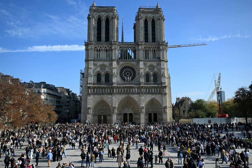
Warnings grow of executions, ethnic cleansing in Sudan’s El-Fasher

Reports were mounting on Tuesday of ethnically motivated atrocities in the western Sudanese city of El-Fasher since its capture by paramilitaries, with allies of the army accusing fighters of executing “more than 2,000” civilians.El-Fasher fell to the Rapid Support Forces (RSF) after more than 18 months of brutal siege warfare, giving the group control over every state capital in the vast Darfur region.Allies of the army, the Joint Forces, said on Tuesday that the RSF “committed heinous crimes against innocent civilians in the city of El-Fasher, where more than 2,000 unarmed citizens were executed and killed on October 26 and 27, most of them women, children and the elderly”.Local groups and international NGOs had warned that El-Fasher’s fall could trigger mass atrocities, fears that Yale University’s Humanitarian Research Lab said were coming true.The monitor, which relies on open source intelligence and satellite imagery, said the city “appears to be in a systematic and intentional process of ethnic cleansing of Fur, Zaghawa, and Berti indigenous non-Arab communities through forced displacement and summary execution”.This included what appeared to be “door-to-door clearance operations” in the city.In a report published on Monday, it said the actions of the RSF “may be consistent with war crimes and crimes against humanity and may rise to the level of genocide”.The same day, UN rights chief Volker Turk spoke of a growing risk of “ethnically motivated violations and atrocities” in El-Fasher.His office said it was “receiving multiple, alarming reports that the Rapid Support Forces are carrying out atrocities, including summary executions”.Pro-democracy activists, meanwhile, said El-Fasher residents had endured “the worst forms of violence and ethnic cleansing” since the RSF claimed control.A video released by local activists and authenticated by AFP shows a fighter known for executing civilians in RSF-controlled areas shooting a group of unarmed civilians sitting on the ground at point-blank range.The paramilitaries have a track record of atrocities, having killed as many as 15,000 civilians from non-Arab groups in the West Darfur capital of El-Geneina.The army, which has been fighting the RSF since April 2023, has also been accused of war crimes.- ‘Harder to unwind’ -More than a year and a half of siege warfare made El-Fasher one of the grimmest places in a war that the UN has labelled among the world’s worst humanitarian crises.Displacement camps outside the city were officially declared to be in famine, while inside it, people turned to animal fodder for food.The UN warned before the city’s fall that 260,000 people remained trapped there without aid, half of them children.The African Union’s chairman Mahmoud Ali Youssouf on Tuesday expressed “deep concern over the escalating violence and reported atrocities”, and condemned “alleged war crimes and ethnically targeted killings of civilians”. The Sudanese army chief, General Abdel Fattah al-Burhan, said on Monday that his forces had withdrawn from El-Fasher “to a safer location”, acknowledging the loss of the strategic city.He pledged to fight “until this land is purified”, but analysts said that Sudan was now effectively partitioned along an east-west axis, with the RSF having already set up a parallel government.Alan Boswell, project director for the Horn of Africa at the International Crisis Group, told AFP: “The longer this war drags on, this division will likely only grow more concrete and harder to unwind.”- Foreign backers -Anwar Gargash, an adviser to the president of the United Arab Emirates, called the city’s capture a “turning point” that showed “the political path is the only option to end the civil war”.The UAE has been accused by the UN of supplying the RSF with weapons, a charge it denies. It is also a member of the so-called Quad — alongside the United States, Saudi Arabia and Egypt — which is working for a negotiated peace.The group has proposed a ceasefire and a transitional civilian government that excludes both the army and the RSF from power.Talks last week in Washington involving the Quad made no progress.The army has its own foreign backers in Egypt, Saudi Arabia, Iran and Turkey, observers have reported. They too have denied the claims.In March, the army retook full control of the Sudanese capital Khartoum, but with both sides now having achieved significant gains neither appears willing to compromise in negotiations.

A close-up of a stack of newspapers resting on a desk, symbolizing information and media.

Pluies record dans le centre du Vietnam: des milliers de personnes évacuées

Des milliers de personnes ont été évacuées au Vietnam après des pluies diluviennes record de plus d’un mètre en 24 heures qui ont submergé la ville de Hué, dans le centre du pays, a annoncé mardi le ministère de l’Environnement.Tandis que des habitants portant des capes de pluies pataugent dans des eaux allant parfois jusqu’à la taille, d’autres circulent à bord de petits bateaux dans les rues inondées de l’ancienne cité impériale avec ses monuments classés au patrimoine mondial de l’Unesco.De 19H00 dimanche à 19H00 (12H GMT) lundi, trois stations d’observation ont mesuré 1,7 mètre, 1,1 mètre, et plus d’un mètre de pluie à Hué, a indiqué le ministère dans un communiqué. L’ancien record, 99 centimètres, avait été établi en 1999.Plus de 8.600 personnes dans quatre régions ont été évacuées depuis samedi en raison de risques de graves inondations et glissements de terrain, d’après le ministère.”C’est la plus grande inondation que j’ai vécue, avec des niveaux d’eau dans ma maison d’à peu près 40 centimètres plus élevés que ceux de 1999″, a déclaré Tran Anh Tuan, un résident de Hué âgé de 56 ans. “Mon rez-de-chaussée est sous environ deux mètres d’eau. Nous avons déplacé tous les meubles importants à l’étage. Nous sommes dans le noir depuis plus d’une journée car l’électricité a été coupée”, ajoute M. Tuan auprès de l’AFP depuis sa maison de trois étages dans le centre de Hué.Les autorités de Hué ont prévenu les résidents que la pluie et les inondations pourraient durer jusqu’à vendredi.- Risque “au niveau le plus élevé” -Dans la ville historique de Hoi An, située non loin de Hué, des touristes ont été photographiés par les médias d’Etat circulant dans des rues étroites à bord de bateaux, et des journalistes de l’AFP ont pu observer les autorités évacuer plusieurs personnes des zones fortement inondées. Tôt mardi matin, de fortes pluies ont provoqué un énorme glissement de terrain de boue rouge sur environ trois kilomètres dans la province côtière de Quang Ngai, à environ 200 km au sud de Hué, isolant environ 1.700 personnes et endommageant les cultures, ont précisé les autorités locales.”Le niveau de risque de catastrophes naturelles dû aux crues soudaines et aux glissements de terrain est au niveau le plus élevé”, a déclaré Mai Van Khiem, directeur du Centre National de Prévisions Hydro-Météorologiques, dont les propos sont rapportés sur un site web gouvernemental, qui précise que davantage de pluies sont prévues jusqu’à mercredi.Des écoles sont restées fermées dans les villes de Hué et Danang depuis samedi, tandis que la voie ferrée reliant le nord et le sud du pays a connu des retards en raison des inondations.Selon les scientifiques, le réchauffement climatique provoqué par l’activité humaine rend les phénomènes météorologiques extrêmes plus fréquents, plus meurtriers et plus destructeurs.Pour chaque degré supplémentaire, l’atmosphère peut contenir 7% d’humidité en plus, préviennent-ils.Début octobre, le nord du Vietnam s’était déjà retrouvé sous de fortes inondations après le passage des typhons Bualoi et Matmo. Les catastrophes naturelles, et principalement les tempêtes, les inondations et les glissements de terrain, ont provoqué la mort ou la disparition de 187 personnes dans ce pays d’Asie du Sud-Est au cours des neuf premiers mois de l’année.

A close-up of a stack of newspapers resting on a desk, symbolizing information and media.

Très puissants et très lents, les ouragans comme Melissa sont plus fréquents

Alimentée par les eaux anormalement chaudes des Caraïbes, la tempête Melissa s’est muée en ouragan de catégorie 5 ne se déplaçant qu’à toute petite vitesse, une combinaison qui pourrait amplifier ses effets, entre vents virulents et pluies diluviennes.Les scientifiques expliquent que des tempêtes qui s’intensifient rapidement tout en stagnant sont en augmentation alors que le climat se réchauffe. – “Marqueur du changement climatique” -D’une tempête tropicale accompagnée de vents soufflant à un peu plus de 110 kilomètres par heure, Melissa est classée en l’espace de 24 heures en ouragan de catégorie 4, avec des vents de 225 km/h. Puis elle s’est encore renforcée en catégorie 5, soit le niveau maximum de l’échelle de Saffir-Simpson.Sur les cinq ouragans de l’Atlantique cette saison, quatre se sont intensifiés de cette manière spectaculaire. “Nous n’avons pas eu tellement d’ouragans dans l’Atlantique cette saison, mais une proportion inhabituelle d’entre eux est passée par une phase d’intensification assez rapide”, déclare à l’AFP Kerry Emanuel, météorologue et climatologue au MIT. Il est difficile d’établir un lien de cause à effet entre le changement climatique et les événements en particulier, mais les scientifiques sont plus confiants lorsqu’il s’agit de tendances.”Pris dans leur ensemble, on pourrait très bien avoir affaire à un marqueur du changement climatique”, poursuit-il. Des températures de surface de la mer plus chaudes injectent plus d’énergie dans les tempêtes, leur donnant du carburant supplémentaire. Mais il faut nuancer: c’est en fait la différence de température entre l’eau et l’atmosphère qui détermine la force potentielle d’un ouragan.”Ce réchauffement atmosphérique tend à réduire l’intensité, et le réchauffement de la température de surface de la mer tend à augmenter l’intensité”, explique à l’AFP David Gilford, scientifique à l’organisation à but non lucratif Climate Central. En général, “la température de surface de la mer l’emporte” dans la détermination de la puissance des tempêtes.Melissa est passée au-dessus d’eaux plus chaudes de 1,4 °C du fait du changement climatique, selon une première analyse de Climate Central – des températures rendues au moins 500 fois plus probables par le réchauffement causé par l’homme.- “Situation terrifiante” -Qui dit océans plus chauds dit aussi tempêtes plus humides. “Nous estimons qu’il y aura entre 25 et 50% de précipitations supplémentaires lors d’une tempête comme Melissa en raison du changement climatique”, juge David Gilford. Facteur aggravant, la tempête avance lentement, à 4,8 km/h. L’ouragan devrait déverser entre 50 et 63 centimètres de pluie sur certaines parties de la Jamaïque.Jill Trepanier, experte en climatologie des ouragans à l’Université d’Etat de Louisiane, évoque la dangerosité des tempêtes comme Melissa. “Il peut s’agir d’ondes de tempête prolongée. Il peut s’agir de précipitations abondantes sur une période prolongée, et le bassin versant ne peut pas le supporter. Il peut s’agir de la vitesse extrême du vent sur une longue période de temps. La plupart des infrastructures ne peuvent pas le supporter”, dit-elle à l’AFP. “Il peut s’agir d’une combinaison des trois éléments”.La scientifique a rédigé un rapport l’année dernière sur les tempêtes stagnantes, relevant que ce type d’événements dans les Caraïbes se produit généralement en octobre, près des côtes. En principe, les tempêtes stagnantes se meurent à mesure qu’elles aspirent de l’eau froide des profondeurs de la mer. Melissa sort de l’ordinaire car elle s’est intensifiée en stagnant au même endroit – un signe que l’eau était si chaude, et la chaleur était si profonde, qu’elle a évité cet effet d’autodestruction habituel.”C’est une situation un peu terrifiante”, constate Mme Trepanier.Selon James Kossin, ancien climatologue de l’Agence américaine d’observation océanique et atmosphérique (NOAA), les données montrent clairement que le nombre de tempêtes stagnantes augmente. Un facteur d’explication possible est “l’amplification arctique” – quand le réchauffement climatique réduit la différence de température entre les basses et hautes latitudes de la planète, ce qui affaiblit les vents faisant normalement avancer les ouragans.Mais des recherches supplémentaires sont nécessaires pour confirmer un lien de causalité, reconnaît-il. 

Jamaica warns of mass destruction as Hurricane Melissa looms

Jamaican officials urged people to get to higher ground and shelters ahead of Hurricane Melissa’s expected landfall Tuesday, with the prime minister warning it could bring massive devastation.The Category 5 storm — which could be the island’s most violent on record — is charting a painstakingly slow path through the Caribbean, and has already been blamed for three deaths in Jamaica, three in Haiti and one in the Dominican Republic.The US National Hurricane Center (NHC) reported on early Tuesday that Melissa was about 115 miles (185 kilometers) from the capital Kingston, and reaching maximum wind speed of 175 miles (280 kilometers) per hour.Its heavy rains combined with intense winds could wreak devastation on par with historic hurricanes, including 2017’s Maria or 2005’s Katrina, which left indelible impacts on Puerto Rico and the US city of New Orleans, respectively.Scientists say human-driven climate change has exacerbated massive storms, increasing their frequency.The Jamaican Red Cross, which has already started to dispatch drinking water and hygiene kits, said Melissa’s “slow nature” was intensifying anxiety.”There’s some areas where landslides are already happening,” the Red Cross’s communications officer Esther Pinnock told AFP.”It’s looking quite eerie on the outside, and every once in a while we have some gusty winds, but the system is creeping in,” Pinnock said. Some “daredevils” have also made the choice to stay on their properties despite urgent warnings, she added.Local government minister Desmond McKenzie said late Monday that many of the island’s 880-odd shelters standing by were empty.”I want to urge persons… to get to high ground as quickly as possible,” he said.According to the International Federation of Red Cross and Red Crescent Societies, some 1.5 million people may be impacted by the storm.- ‘Saving lives’ -Jamaican Prime Minister Andrew Holness said the island’s western end faced the worst destruction.”I don’t believe there is any infrastructure within this region that could withstand a Category 5 storm, so there could be significant dislocation,” he told CNN.But despite pleas to evacuate, many Jamaican residents were staying put.”I am not moving. I don’t believe I can run from death,” Roy Brown told AFP in Kingston’s seaside area of Port Royal.The plumber and tiler said he was reluctant to flee because of his past experiences with the poor conditions of government hurricane shelters.Fisherwoman Jennifer Ramdial agreed, adding: “I just don’t want to leave.”Holness told a press briefing that the evacuation was about “the national good of saving lives.””You have been warned… Make the right decision.”Part of Melissa’s punch stems from its slow pace: it is lumbering along slower than most people walk, at just three miles per hour or less.That means areas in its path could endure punishing conditions for far longer than during most hurricanes.- ‘Catastrophic’ -“You anticipate that maybe within four hours it would be gone… but Melissa is not looking like that type of a storm,” said Pinnock of the Jamaican Red Cross.The NHC warned of “catastrophic” winds and flash flooding on the island on Tuesday that could cause lengthy power and communications outages, along with “extensive infrastructural damage.”Up to 40 inches (one meter) of rainfall are forecast, with flash flooding and landslides also expected in Haiti, the Dominican Republic and Cuba.A “life-threatening” storm surge is likely along Jamaica’s southern coast, with waters potentially rising 13 feet (4 meters), along with “destructive waves,” the NHC said.In the farming community of Flagaman in the south, residents hunkered down in a store.Owner Enrico Coke said he opened his place for fear that his neighbors had nowhere to go: “I’m concerned about farmers, the fishermen will be suffering after this.””We’ll need help as soon as possible.”- ‘Water kills’ -After pummeling Jamaica, Melissa is forecast to cross over eastern Cuba on Tuesday night.On Monday, officials in Jamaica said three people had died while preparing for the storm, cutting tree branches and working on ladders. In the Dominican Republic, a 79-year-old man was found dead after being swept away in a stream, officials said. A 13-year-old boy was missing.Haiti’s civil protection agency said three people died in storm conditions over the weekend.Meteorologist Kerry Emanuel said global warming was causing more storms to rapidly intensify as Melissa did, raising the potential for enormous rains.”Water kills a lot more people than wind,” he told AFP.The last major hurricane to impact Jamaica was Beryl in July 2024 — an abnormally strong storm for the time of year.”Human-caused climate change is making all of the worst aspects of Hurricane Melissa even worse,” said climate scientist Daniel Gilford.